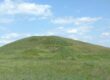

For the first time in our experience, we received an appropriate response from the State Service of Ukraine for Geodesy, Cartography and Cadastre (Derzhheokadastr) to our complaint. Officials confirmed that the plots of land in question had been illegally occupied and damaged. This was in response to our appeal to inspect lands that were officially placed under conservation in 2010 but have, in fact, been continuously plowed.
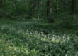
The case involves 68 hectares of pastures and hayfields in the Hvardiiska community of the Khmelnytskyi region. According to the regional office of the StateGeoCadastre, the plots have not been officially granted for use.
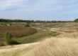
Nevertheless, one plot (6825082700:05:003:0001) was plowed by agricultural companies in 2022, while another (6825081800:02:003:0001) has been continuously used since its conservation and the plowing has even been expanded.
What’s noteworthy is that the public officials used the government’s crop map to confirm that corn and sunflower are being grown on the plots. Finally, digitalization has reached the StateGeoCadastre in the context of state control.
Now all of this data has been submitted to the district prosecutor’s office. We hope that in the near future, the plots will be re-conserved and restored to their natural state, and that the perpetrators will be held accountable.