
Yesterday, we completed a two-month course on “Modern Use of GIS Technologies in Nature Conservation” for students and lecturers at the Vasyl Stus Donetsk National University.
Participants learned to use QGIS to identify legal violations, plan the establishment of new protected areas, and prepare for field expeditions. They mastered skills for working with the GBIF (Global Biodiversity Information Facility) database, using the QFIELD app during expeditions, and processing collected data. Particular attention was paid to using Sentinel satellite imagery and the EFFIS (European Forest Fire Information System) monitoring service.
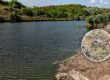
At the end of the course, each participant applied their new skills in a practical exercise. Some found violations like the plowing and illegal appropriation of land within nature reserves. Others uncovered illegal construction and land grabbing on the banks of rivers not included in the State Water Cadastre. A few identified the failure to account for Red Data Book of Ukraine species in forest management plans.
GIS technologies, combined with open state registries, proved to be an effective tool for detecting violations and holding perpetrators accountable. Based on the materials collected, complaints and appeals have already been prepared for the relevant authorities.
Unfortunately, much of what the students found in just a few hours of practical work has been ignored for years by the very agencies responsible for these issues. But who, if not today’s students, will become the new generation of specialists capable of changing this situation tomorrow?
We plan to continue our cooperation with Donetsk National University and other higher education institutions to transfer knowledge and support new conservation initiatives. And who knows—maybe this spring, we’ll invite students and lecturers to participate in an expedition to a large, picturesque, and very wet swamp! =)