
Ukraine’s government has developed a national crop map, a tool designed to track what crops farmers are growing and on what areas of land. Initially, it was created for monitoring agricultural production and distributing subsidies, but we have found another valuable use for it.
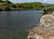
The crop map is based on satellite imagery analysis, which allows it to track changes in land use. It displays not only fields but also rivers, forests, bodies of water, bogs, and uncultivated lands. This makes it possible to quickly identify violations, such as unauthorized land occupation and the plowing of coastal protection zones, pastures, and hayfields.
We have begun to use the crop map to monitor such violations and have already seen our first results. Thanks to our appeals, we have managed to stop the illegal plowing of coastal zones and the unauthorized land occupation by farmers in four cases. The State Environmental Inspectorate (Derzhekoinpektsia) confirmed the violations and handed the cases over to the police for further investigation.
However, a question arises: if the map is publicly available, why don’t state agencies—such as the State Service of Ukraine for Geodesy, Cartography and Cadastre (Derzhheokadastr) and the State Environmental Inspectorate—use it for systematic monitoring? Why are environmental and economic crimes being noticed by the public and not by the government?
The solution is obvious: state bodies should be using the crop map for control and prompt response to violations. If such an effective monitoring tool exists, why isn’t it being used to protect the environment?